|
Earth's Gravity Definition
The Geoid
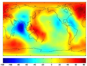
When scientists discuss the gravity field and shape of the Earth, they often do so in terms of a surface called the geoid. This is the surface that most closely approximates sea level in the absence of winds, ocean currents, and other disturbing forces. The Earth's shape resembles an ellipsoid (its equatorial radius is about 21 kilometers (13 miles) greater than its polar radius) but it is not a perfect ellipsoid. Because of this resemblance, an ellipsoid is used to approximate the bulk of the Earth's shape, and departures from the ellipsoid are represented by the geoid elevation above or below the ellipsoid. The geoid can be as low as 106 meters (350 feet) below the ellipsoid or as high as 85 meters (280 feet) above.

The Earth's Geoid
Gravity Anomalies
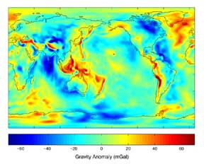
The Earth's gravity field is determined by how the material that makes up the Earth is distributed throughout the Earth. Because gravity changes over the surface of the Earth, the weight of an object changes along with it. One can define standard gravity as the value of gravity for a perfectly smooth 'idealized' Earth, and the gravity 'anomaly' is a measure of how actual gravity deviates from this standard. A map of gravity anomalies (usually expressed in units of milliGals) tends to highlight short wavelength features better than a map of the geoid.

Gravity Anomalies from GGM01S
|


