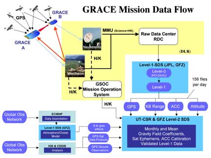
 GRACE Mission Data Flow The long-term average distribution of the mass within the Earth system determines its mean or static gravity field. The motion of water and air, on time scales ranging from hours to decades, largely determines the time variations of Earth's gravity field. The mean and time variable gravity field of the Earth affect the motion of all Earth satellites. The motion of twin GRACE satellites are affected slightly differently since they occupy different positions in space. These differences cause small relative motions between these satellites, designated GRACE-A and GRACE-B. The distance changes are manifested as the change in time-of-flight of microwave signals between the two satellites, which in turn is measured as the phase change of the carrier signals. The influence of non-gravitational forces on the inter-satellite range is measured using an accelerometer, and the orientation of the spacecraft in space is measured using star cameras. The on-board GPS receivers provide geo-location and precise timing. An overview of the mission is discussed in Tapley et al. (2004, Geophys. Res. Lett. 31, L09607, doi:10.1029/2004GL019920). Early science results have appeared in several journals in 2004 & 2005, and are accessible with any literature search tool. The responsibility for extraction of Earth gravity models is with the GRACE project Science Data System (SDS). The SDS is distributed between UTCSR, JPL and GFZ. At present, the SDS delivers monthly models of Earth gravity field, and distributes it to public via PO.DAAC and ISDC (links below) after validation. The GRACE data is divided into three levels. The raw data, collected from satellites, is calibrated and time-tagged in a non-destructive (or reversible) sense, and labeled Level-1A. Level-1A data products are not distributed to public. These data undergo extensive and irreversible processing, and are converted to edited and cleaned data products are 1-5 second rates. The products. labeled Level-1B, include among others, the inter-satellite range, range-rate, range-acceleration, the non-gravitational accelerations from each satellite, the pointing estimates, the orbits, etc. The Level-1B products are processed to produce the monthly gravity field estimates in form of spherical harmonic coefficients. Occasionally, several months of data are combined to produce an estimate of the mean or static gravity field. These estimates are labeled Level-2. After validation, all Level-2 and accompanying Level-1B products are released to the public through two portals. One is the Physical Oceanography Distributed Active Archive Center (PO.DAAC) at the Jet Propulsion Laboratory, Pasadena, USA. The other is the Information System & Data Center (ISDC) at GeoForschungsZentrum Potsdam in Germany. The monthly estimates are only distributed through the PO.DAAC or ISDC websites. The mean or static gravity field products, such as GGM02, are also distributed through this site. The GRACE gravity field data products as well as supporting documentation may be accessed at At present (Aug 02, 2007), both Atmospheric and Ionospheric radio occultation data is available from GRACE. All GRACE Radio Occultation data products may be accessed at For the convenience of users who would prefer to access GRACE data products as mass anomalies (e.g. water layer), certain standardized products and tools are available from other groups. These Level-3 Data Products are available through several groups. |

