|
GRACE Publications |
|
GRACE 2002: A Scientific Geodesy Gravity is the invisible force that pulls two masses together. The branch of science dealing with obtaining precise measurements of the Earth, mapping points on the surface,and studying its gravitational field is known as geodesy. Producing a precise model of the fluctuations in gravity over the Earth’s surface has proven to be a formidable task. Currently, data from several dozen satellites must be combined to produce a model of Earth’s gravitational field.These models do a good job at replicating the large-scale features of Earth’s gravitational field but cannot resolve finer-scale features or accurately describe the small month-to-month variations associated with the hydrologic cycle.The unique design of the GRACE mission (twin satellites flying in formation) is expected tolead to an improvement of several orders of magnitude in these gravity measurements and allow much improved resolution of the broad-to finer-scale features of Earth’s gravitational field over both land and sea.
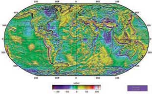
This is a plot of the Earth’s geoid (surface of equal gravitational potential) produced by the Earth Gravitational Model (EGM96), one of many models used for gravity studies. The Space Geodesy Branch of NASA Goddard The distribution of mass over the Earth is non-uniform. GRACE will determine this uneven mass distribution by measuring changes in Earth’s gravity field.The term mass refers to the amount of a substance in a given space, and is directly correlated to the density of that substance. For example, a container filled with a more dense material, like granite, has more mass than that same container filled with water. Because mass and density are directly related, there is also a direct relationship between density and gravity. An increase in density results in an increase in mass, and an increase in mass results in an increase in the gravitational force exerted by an object. Density fluctuations on the surface of the Earth and in the underlying mantle are thus reflected invariations in the gravity field.As the twin GRACE satellites orbit the Earth together, these gravity field variations cause infinitesimal changes in the distance between the two. These changes will be measured with unprecedented accuracy by the instruments aboard GRACE leading to a more precise rendering of the gravitational field than has ever been possible to date. GRACE will do more than just produce a more accurate gravitational field plot, however.The measurements from GRACE have important implications for improving the accuracy of many scientific measurements related to climate change. Substantive advances in the interpretation of satellite altimetry, synthetic aperture radar interferometry,and digital terrain models, covering large land and ice areas used in remote sensing applications and cartography, will result from the improved gravitational field measurements provided by GRACE.These techniques provide critical input to many scientific models used in oceanography, hydrology, geology and related disciplines, and,for this reason, the Earth Science community eagerly anticipates the GRACE launch.The next few pages present some of the expected scientific applications.
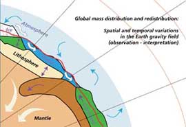
This schematic diagram illustrates the different forces that redistribute mass on the surface of the Earth. Since mass changes and gravity changes are correlated, the data retrieved by the GRACE satellite should help scientists better quantify these movements and their impact on the Earth’s climate.(Image provided by GFZ.) |