|
Education Gravity Models Instruments Launch Preparation Launch Vehicle Links to Resources Other Images Spacecraft Video/Animation File |
Unless otherwise noted, images are provided by University of Texas
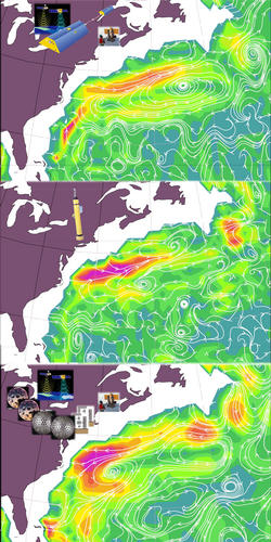
Center for Space Research and NASA. High Resolution JPG 3 MB The figure shows three datasets, whose arrows show ocean currents off the East coast of the U.S, 1000m beneath the surface. The top panel is obtained from the GRACE geoid, satellite altimetry, and ship measurements of temperature and salt. The bottom panel only differs from the top one in the fact that the best geoid prior to GRACE launch is used there. The middle panel shows direct measurement of those currents by floats deployed from ships. This region of the N. Atlantic, showing the Gulf Stream, is one of the best studied in the World's Oceans, and where the amount and quality of data from shipborne instruments is highest. In data poor regions, the new information provided by GRACE together with satellite altimetry will increase our knowledge of ocean circulation. Colors: grey: land, white: lack of data; others: the height of the sea surface above the geoid. Currents flow around these highs and lows, much as wind flows around highs and lows of atmospheric pressure. |
