|
GRACE Publications |
|
UT/NASA Gravity Model Provides Extraordinary Accuracy to Oceanographers July 21, 2003
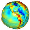
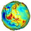
Dr. Byron D. Tapley, UT Austin aerospace engineering professor, the mission's principal investigator, presented the model, called GGM01, at the International Union of Geodesy and Geophysics meeting in Japan on July 10. GGM01 has already shown remarkable value in improving predictions of weather and climate change. "This initial GRACE model represents a major advancement in our knowledge of Earth's gravity. Pre-GRACE models, which were created with data from multiple sources with uneven quality and incomplete geographic coverage, contained such large errors that many measurement errors were obscured," said Tapley. The release of this preliminary model is a major advancement for oceanographers and a taste of scientific advancements yet to come from GRACE. It has dramatically improved the study of ocean currents, said Tapley, information that could eventually be used to learn more about meteorological events such as El Niño and the rate at which polar ice caps are melting, as well as other natural occurrences. Other expected applications of GRACE include tracking water movement on and beneath Earth's surface, tracking the movement of ice sheets, improving information on sea-level heights and sea-level rise and tracking changes in the interior structure of the earth. Jointly implemented by NASA and the German Aerospace Center (Deutsches Zentrum fur Luft und Raumfahrt, or DLR) under the NASA Earth System Science Pathfinder Program in 1997, GRACE was launched on March 17, 2002 as the beginning of a five-year flight mission. GRACE consists of two identical satellites in near circular orbits, separated from each other by approximately 137 miles. As the satellites orbit the Earth, gravity field variations cause minute changes in the distance between the two. These changes are measured with unprecedented accuracy by the instruments aboard GRACE, leading to a more precise rendering of the gravitational field than has ever been possible to date. Every 30 days GRACE will produce gravity maps that will be up to 1,000 times more accurate than current maps, substantially improving the accuracy of many techniques used by oceanographers, hydrologists, glaciologists, geologists and other scientists to study phenomena that influence climate. GRACE Mission: GRACE Gravity Model: NASA Earth System Science Pathfinder Program: Download the PDF. |
 Improved weather and climate change predictions now result from a model of Earth's gravity field 10 to 50 times more accurate than previous models, thanks to engineers at The University of Texas