|
GRACE Publications |
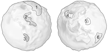
Gravity By GRACE This lithograph displays the most accurate map to date of Earth's long wavelength gravity field and is the first version to be released by NASA's Gravity Recovery and Climate Experiment (GRACE) mission. We call these maps gravity anomaly maps because they show us how much Earth's actual gravity field departs from "normal," as defined by a simplified mathematical gravity model that assumes the Earth is perfectly smooth and featureless. The maps reveal that the Earth is a restless, dynamic planet, both at its surface and deep within its interior. These gravity anomaly maps are derived from data gathered during the first 111 days of the GRACE mission. The gravity anomalies (measured in milligals-a unit of gravity acceleration named after Galileo) represent departures that are only about one-millionth the strength of the Earth's average gravity field. Yet even with such small anomalies, GRACE is sensitive enough to detect these gravity variations and produce detailed maps like the ones shown here. In fact, it is expected that GRACE will eventually be able to detect anomalies approaching one-billionth the strength of the Earth's average gravity field. The globe on the left side shows some of the prominent gravity anomalies in the Western Hemisphere, and the globe on the right side focuses on the Eastern Hemisphere. The red and yellow areas depict regions where Earth's measured gravity field is stronger than normal (positive gravity anomalies) while the shades of green and blue indicate areas where the gravity field is weaker than normal (negative gravity anomalies). The anomalies are indicative of various geophysical processes. The Himalayan/Tibetan Plateau region, an uplifted area created by colliding tectonic plates, displays a prominent pattern on the anomaly map. The North Atlantic Mid-Atlantic ridge is an active spreading center where new crust is being created, and shows up as a strong positive anomaly in the middle of the Atlantic. The largest negative anomaly observed is in the Puerto Rico Trench/Lesser Antilles region, where two tectonic plates move past one another. The Andes Mountains and Tonga/Kermadec regions are related to subduction processes where one tectonic plate slides under another. The same general pattern is observed in the Mariana Arc-Trench region, also indicated on the map. This is another subduction region that has created a chain of islands and the deepest ocean trench in the world at 11,033 m (36,198 ft).
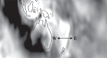
A closer look at the Tonga/Kermadec region (see closeup) provides a good example of how much additional detail GRACE can provide over previous satellite gravity measurements. As we move from east to west (see front) across this region we observe in the gravity anomaly map a moderate positive anomaly (yellow), a negative anomaly (blue/green), a strong positive anomaly (red), and drop to a weaker positive anomaly (yellow), all in a relatively small area. This observation is consistent with the patterns observed by previous high-resolution ground-based measurement techniques (i.e., gravity data obtained from airplanes and ships), but until now could not be observed on a global scale by a satellite. Previous satellite measurements would show a broad diffuse positive anomaly in this entire area. The new measurements made by GRACE allow us to see much more detail and evidence of the individual smaller scale processes that are at work as the Pacific Plate is being thrust down under the Australian Plate. The maps shown here demonstrate that various geophysical features generate gravity anomalies with considerable spatial variation over the surface of the Earth. There are other mass variations that occur on shorter timescales, such as the movement of water masses as they seasonally cycle between the atmosphere, oceans, continents, glaciers, and polar ice caps. GRACE is the first gravity measurement that can successfully monitor these types of changes. The movement of these water masses will be detectable as changes in sequentially measured GRACE monthly average gravity field maps. Scientists expect to compare high accuracy GRACE gravity field maps from one month to the next in order to track changes in the distribution of mass in Earth's atmosphere, oceans, and ice masses. The innovative design of GRACE involves twin satellites flying in formation with the distance between them varying ever so slightly in response to changes in mass at or below the Earth's surface. GRACE can sense these minute variations and record them along with Global Positioning System coordinates of the location. This information is later processed by the GRACE Science Team and used to produce monthly average maps of the Earth's gravity field. eruptions. These new gravity measurements will be used for many important applications, including:
This enhanced knowledge should lead to a better understanding of the forces that drive El Niño and La Niña, more accurate seasonal forecasts of Earth's weather patterns, an ability to track the changing distribution of water resources in critically important land aquifers, and improved forecasting of natural hazards. GRACE Partners GRACE is part of NASA's Earth Science Enterprise, whose mission is to understand and protect our home planet. It is a joint partnership between NASA in the United States, and the Deutsches Zentrum für Luft und Raumfahrt (DLR) in Germany. The Principal Investigator is Dr. Byron Tapley of the University of Texas Center for Space Research (UTCSR), and the Co-Principal Investigator is Dr. Christoph Reigber of the GeoForschungsZentrum (GFZ). NASA's Jet Propulsion Laboratory has responsibility for the Project Management of GRACE, and NASA's Goddard Space Flight Center maintains responsibility for Mission Management. For further information on the GRACE mission, including a full educational curriculum that includes numerous classroom exercises for K-12 visit: http://www2.csr.utexas.edu/grace
PDF Version |


