|
GRACE Publications |
|
Studying ocean currents both near the surface and far beneath the waves If the ocean were motionless, the sea surface would still have hills and valleys.This static topography of the ocean is caused by the fluctuations in the gravity field caused by variations in density over the surface of the ocean. Because the oceans are always in motionswept by winds, seething with waves, and circulating in gigantic currents and gyres driven by surface winds and by the rotation of the Earththe shape of the oceans topography cannot be determined by static gravity measurements alone.An additional component, known as the dynamic topography must be accounted for to precisely measure the shape of the ocean surface at any given time.Although dynamic topography only accounts for about one percent of the total variation of the oceans topography, it is an extremely important component for it contains important information about the speed and direction of ocean currents. Consequently, scientists would very much like to improve their ability to measure and track changes in dynamic topography.
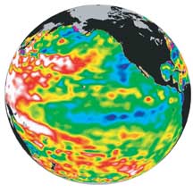
This image shows sea surface topography data from TOPEX/Poseidon. When such data are combined with the precise geoid measurements expected from GRACE, scientists should be able to study currents from satellites using a technique known as dynamic topography. This image was acquired in March 2001 in the aftermath of earlier El Niño/La Niña conditions in the tropical Pacific. Areas toward the blue end of the spectrum represent anomalously low sea surface heights for March and areas toward the red end represent anomalously high values for March.
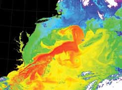
GRACE data should help scientists understand the role ocean currents play in regulating Earths climate.This image from the MODIS sensor onboard the Terra satellite shows the Gulf Stream (red), a surface ocean current that plays a critical role in redistributing heat from the tropics to the poles. It has a moderating influence on the climate of Northwest Europe, which would otherwise be much colder similar to other locations at the same latitude, such as Greenland. This particular image was obtained on May 2, 2001 and was provided by Liam Gumley of the MODIS Atmosphere Team, University of Wisconsin-Madison Cooperative Institute for Meteorological Satellite Studies. Two pieces of information are needed to make a dynamic topography measurement, sea surface height and a model for the Earths geoid. Since the impact of dynamic topography on the shape of the ocean surface is quite small compared to the impact of the static gravity field, the measurements must be extremely precise and of high resolution. Satellite altimeter measurements from TOPEX/Poseidon and Jason-1 can provide this level of detail for sea surface height measurements, but to date, there are no geoid measurements with sufficient precision and resolution to allow satellite-derived measurements of dynamic topography. Scientists expect the data returned by GRACE to provide the precise, high resolution geoid measurements required to measure dynamic topography affects.They hope to use these data to better understand the role that ocean currents play in regulating the Earths climate. Ocean currents regulate Earths climate by transporting heat from equatorial regions to the poles.The Earth's oceans essentially serve as huge heat reservoirs and currents both at the ocean surface and far beneath the waves known as deep ocean currents act as massive conveyor belts that distribute this heat over the surface of the Earth. Consequently, any changes in these equator-to-pole conveyor belts could significantly change the weather all around the globe. Scientists are particularly hopeful that GRACE will help them better understand the role that deep ocean currents play in regulating climate. Until now, deep ocean currents have remained shrouded in mystery since they have been very difficult to measure. However, the design of the GRACE satellites makes them ideally suited to examine deep ocean currents and should lead to improved ability to track them and study their impact on global climate.
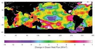
This map illustrates the heat exchange flux over Earths oceans for a five year period. A negative value indicates an area where the ocean is losing heat while a positive value indicates an area where the ocean is absorbing heat. Ocean heat exchange flux plays a crucial role in regulating the Earths climate and data from GRACE should help improve the accuracy of these measurements. |