|
GRACE Publications |
|
Tracking changes in ice sheets and changes in global sea level The question of whether ice caps are shrinking or growing is important for climate change studies. As the area covered by ice sheets decreases, the surface area of the Earth’s oceans increases, leading to increased heat absorption and rising temperatures. This, in turn, melts more ice and contributes to global sea level rise. Data provided by GRACE will help scientists better understand how ice sheet mass is changing and the impact the changes are having on global sea level. GRACE data, when combined with height variations measured with ground-based, aircraft, and satellite instruments, like the Geoscience Laser Altimeter System (GLAS) on the Ice, Clouds, and Land Elevation Satellite (ICESat), will allow for improved computations of ice sheet mass balance. Also by combining the GRACE gravity field measurements with surface elevation measurements (such as from radar altimeters), scientists will be better equipped to distinguish between the mean ocean level changes due to thermal expansion and those due to actual redistribution of water.
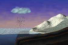
The issue of long-term changes in ice sheet mass is an important one for climate studies, and data from GRACE should help scientists quantify these changes. The diagram illustrates the idea that as the ice sheet melts, the increased surface area of open water absorbs more heat, raising temperatures, melting more ice, and also contributing to sea level rise.
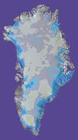
GRACE will be able to precisely measure very small changes in Earth’s gravitational field that result from changes in the mass of ice sheets. Shown here is computer generated image of Greenland that shows how the ice mass is changing. Blues indicate areas where the loss of ice is greatest, and yellows indicate regions that are apparently thickening. Gray areas indicate no significant change in ice thickness.
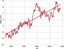
Satellite altimeters such as those on TOPEX/Poseidon and Jason-1 can measure the total mean sea level change, as illustrated here with TOPEX/Poseidon data from 1993 to the middle of 2001. However, the altimeter alone cannot distinguish between what portion of the observed anomaly can be attributed to warming of the ocean and what part is due to water being added from melting ice sheets. Data provided by GRACE, used in conjunction with altimeter measurements like those shown here, should help scientists better distinguish between these two phenomena. (Image courtesy of Don Chambers, University of Texas, and Steve Nerem of the University of Colorado.) For example, data from GRACE is expected to greatly improve scientists’ understanding of how much global sea level is being impacted by a phenomenon known as postglacial rebound. Postglacial rebound refers to the slow rebounding of the Earth’s crust that is occurring now that the weight of the ice from the last Ice Age is no longer present.The rebounding of the crust can affect relative sea level at the coastline in a manner that varies from place to place.This can confound efforts to determine how much of the overall observed change in sea level is actually caused by thermal expansion of the oceans resulting from global warming.
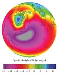
Postglacial rebound accounts for the vertical movement of land in many parts of the world.These shifts, which have been continuing since the last Ice Age ended, affect relative sea level at the coastline in a manner that varies from place to place. Such movements can confound tide gauge records obtained from coastal sites and thus complicate efforts to track the overall change in global sea level. The data retrieved by GRACE will be combined with the previously mentioned altimeter readings to get a better handle on how much of the perceived change in sea level is attributable to the phenomenon of postglacial rebound and how much might be attributed to global warming.This particular image depicts the predicted time rate of change in geoid height expected to result from postglacial rebound as predicted by the ICE-4G (VM2) Toronto model (Image provided by W.R. Peltier, University of Toronto, Canada.) |