DLR Hompage NASA Homepage GFZ Homepage CSR Homepage GRACE Homepage
GRACE - Gravity Recovery and Climate Experiment Homepage
Home Science Operations Mission Flight Systems CSR
Games Education Publications Gallery Search

RL05 Products (Updated: 2013-02-08)

The GGM05 Models

Science Data Products

Level-3 Data Products

Science Team Meeting


Gravity Measurement

GPS Occultation Measurement

Other Science Contributions

Technical Science Information

GRACE Partners

Download Adobe Acrobat Reader


SDS - internal

Science - internal
GRACE Gravity Model 05 - Released 2016

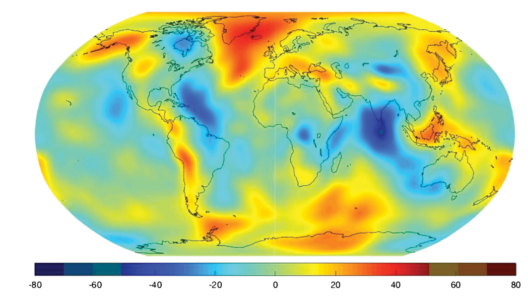
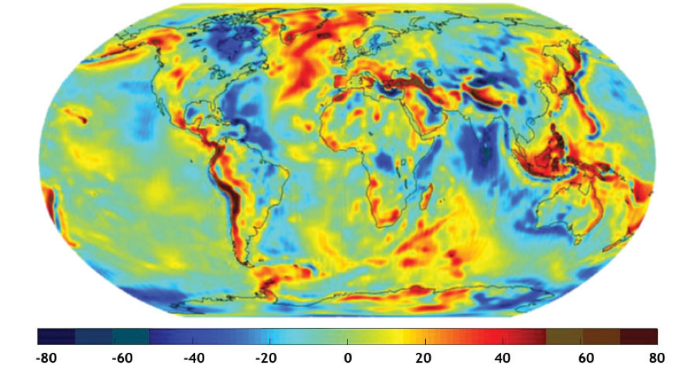
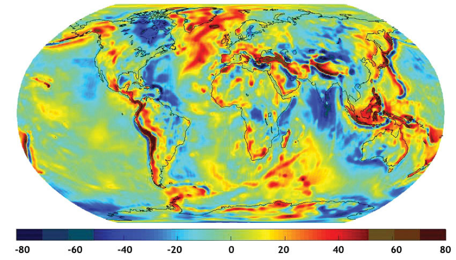
The global Earth gravity model, GRACE Gravity Model 05 (GGM05) is a significant improvement upon, and supersedes, the previously released models GGM01, GGM02 and GGM03.

The GGM05S model is based on the analysis of ten years of GRACE in-flight data, spread between January 2003 and May 2013. GGM05G combines GGM05S with GOCE gradiometer data spanning November 2009 to the end of the mission in October 2013. The GGM05C gravity model was estimated to spherical harmonic degree and order 360 from a combination of GRACE and GOCE gravity information (based on GGM05G) and surface gravity anomalies from DTU13.

The GGM05 model suite is released with the following information available: :

The GGM05 models should be cited as: J. Ries, S. Bettadpur, R. Eanes, Z. Kang, U. Ko, C. McCullough, P. Nagel, N. Pie, S. Poole, T. Richter, H. Save, and B. Tapley (2016) Development and Evaluation of the Global Gravity Model GGM05, CSR-16-02, Center for Space Research, The University of Texas at Austin.

For more information, please contact the Center for Space Research at 512-471-5573 or e-mail: grace@csr.utexas.edu.

Further Progress in Measuring the Earth's Gravity Field
Prior to GRACE, the long-wavelength part of the Earth's gravity field from space was determined from various tracking measurements of Earth orbiting satellites. These measurements were of considerably varying vintage and quality, and of incomplete geographical coverage. Consequently the accuracy and resolution of the Earth gravity field models were limited, with most of the satellite contributions limited to wavelengths of 700 km or longer. At shorter wavelengths, the errors were too large to be useful. Only broad geophysical features of the Earth's structure could be detected. As a result, improvements to the Earth gravity models at medium & short wavelengths had to come from the use of measurements of terrestrial or marine gravity - also of varying vintage, quality and geographic coverage.

Gravity anomalies from decades of satellite tracking data prior to GRACE (in mgal)
Gravity anomalies from decades of satellite tracking data prior to GRACE

With the advent of the GRACE mission, the resolution has been steadily improved as more GRACE data has accumulated and the gravity determination strategies and background models have made more accurate. The new GGM05 model builds upon the experience with the older GGM01, GGM02 and GGM03 models. In addition, the satellite gradiometry data available from the GOCE mission by ESA allows the extension of the gravity field resolution from about 100 km from GRACE only to about 50 km with the GRACE/GOCE combination. In the following images, the dramatic increase in the resolution of the satellite-determined gravity field can be seen clearly.


Gravity anomalies from 363 days of GRACE data (GGM02S)

Gravity anomalies from ten years (2003-2013) of GRACE data (GGM05S)

Gravity anomalies from ten years (2003-2013) of GRACE data and four years of GOCE data (GGM05G)

A milligal is a convenient unit for describing variations in gravity over the surface of the Earth. 1 milligal (or mGal) = 0.00001 m/s2, which can be compared to the total gravity on the Earth's surface of approximately 9.8 m/s2. Thus, a milligal is about 1 millionth of the standard acceleration on the Earth's surface.

Applications

These gravity field model improvements allow solid Earth scientists to more accurately infer the Earth's internal structure at finer resolution than ever before possible from space. Ocean scientists can combine this gravity model with ocean height measurements from satellite altimeters to study global ocean circulation on a finer scale than has been previously possible. These will, in turn, enable a better understanding of the processes that drive the Earth's dynamic system (solid Earth, ocean and atmosphere), thus leading to better analysis and predictions of climate change & natural hazards. In addition, GRACE allow hydrologists to monitor entire the water in underground aquifers and entire river basins, providing better information for decisions about drought mitigation and flood hazards.

Go to the UTopia web site
Go to University of Texas web site

|  HOME   |  SCIENCE   |  OPERATIONS   |  MISSION   |  FLIGHT SYSTEMS   |  CSR   |
|  GAMES   |  EDUCATION   |  PUBLICATIONS   |  GALLERY   |  SEARCH   |

The GRACE mission is jointly implemented by NASA and DLR under
the NASA Earth System Science Pathfinder Program.

Last Modified: Mon Jan 06, 2020